After a good night rest we woke up at 7:00 AM and had a good breakfast. We filled our bottles with hot tea and around 8:00 we left the hut and started a new day hike. This day we planned a shorter hike. We realised only when it was already too late that we could have easily continued till Öschinensee in the same day.
The day before we were too exhausted to take any photos with the Gamchigletchger. We were hoping to make some on our way out of the Gspaltenhornhutte but we had to skip it due to the morning fog.

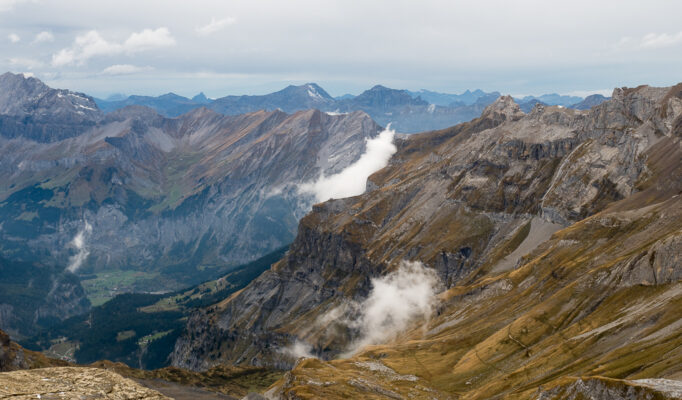
Looking back at Gspaltenhornhütte
The scenery on this stage was spectacular with bleak areas at the higher altitudes. The Hochtürli pass is the highest altitude on the whole Alpine Pass Route. Looking back, this section was steep, high and wild, exhilarating but daunting.
The morning fog was coming towards the glacier from the valley, creating little holes and exposing the blue sky in the pass, it looked spectacular.

Morning hike as the fog lifts up
The path to the glacier was an easy one and well marked, we were also extra careful not to repeat the same error as in the previous day. Once we reached the crossing we followed the markings towards Bundalp, Hochtürli. From place to place one can also see markings ensuring that this is the right path towards Blümlisalphütte.
It was our first time walking on a glacier. We descended and passed the bridges over the moraines. On our way we saw ibexes standing up on the rocks. Then the road started to go up but it was quite an enjoyable hike. You could see the whole valley from there.

Crossing the bridges over the Gamchigletscher
Crossing the glacier was an interesting experience, there is an impressive canyon opening up with water flowing from the sides and into the valley.

Canyons and crevasses in the glacier
Passing the glacier and reaching the higher areas that are dominated by typical scree vegetation we managed to take some macro photos as well. We also noticed that the actual glacial flood plain is used by alpine farmers.
On this path we also met a couple of friendly hikers and while exchanging impressions about the road and the state of Sefinefurgge we heard some interesting stories. One of the couples asked us where we come from. Hearing that we are Romanians they told us how they smuggled some persons out of the country during the communist regime.

First stage to Hochtürli
As we started to go up towards Hohtürli, it became tougher and tougher. It’s was quite steep and wet but not very exposed. Some parts were covered with snow and mud, but nothing compared with the adventure from the day before.

The steep and windy trail up to Hochtürli
The hard part was at the end, as every day the end was the hardest part. This consisted of a very steep portion of long wooden stairs, placed in a zig-zag pattern but having fixed chains to hold on to. They were never ending … but after some struggle we finally reached the top and saw the Blümlisalphütte.

Stairs up to Bluemlisalphutte
Reaching the top we had an impressive view. On one side was Blüemlisalphutte, high up in the distance and surrounded by snow.

We have finally made up to Blümlisalphütte
The other side was completely the opposite, sunny with cloud patches, offering a high vantage point.

View in the valley from Blümlisalphütte
The hut was nice and spacious, although it was quite a bit cold and in that they they had problems with the water. We had to use the outside restroom and every trip was quite an adventure due to the strong wind.
We were quite early in the hut (14.00) and decided to take the lunch and browse through the books. We found a great book listing all the Swiss huts, and warted already to make some future plans. Sitting and looking through the books we ended up talking with a nice guy. He was British, studied in Scotland and having a French origin.
Just before dinner a large group o hikers joined, they were also struggling with the wind on the way up, as the foehn was fighting the bad weather on the other side of the mountain.

Bluemlisalphütte
Photos, Downloads and References
- The complete photo gallery
- The recorded GPS track (please note that it also contains all the mistakes we did on the hike)
- The topographic map in SchweizMobil
Track Details and Elevation
Total climbing: 1041 m
Total descent: -603 m


